Trail Maps of HCLT Public Access Areas

|
HCLT Hiking Trails around Highlands
Highlands-Cashiers Land Trust has several trails in Highlands that are open to the public. Check out our Trails Map or scroll down for maps of individual properties.
Coming Soon: Hiking Trails in Cashiers at our newly conserved property, Edward Baker Preserve! |
|
|
Brushy Face Preserve
Difficulty: Moderate. Heading out from the trail head at the cul-de-sac, the trail crosses through a wide range of habitats and over Clear Creek. Length: 1.2 mile loop. Watch a video of Brushy Face EcoScenes |

|
|
|
Dixon Woods Park
Difficulty: Easy. A network of trails, including a trail around Dixon Pond, covers the flattest of our properties in Highlands. Length: Over 1 mile of trails. Dixon Woods info and Directions 
|
|
|
Kelsey Trail Preserves
Difficulty: Moderate. From the end of North 5th Street, the trail follows an old oxcart trail along a creek and connects to Rhododendron Park. Length: 1 mile round trip. 
|
|
|
McKinney Meadow
Difficulty: Easy. From the Cashiers Crossroads, take 107 S for ½ mile. Turn slight right onto Cashiers School Rd. Limited parking is on the left. This is a native mountain meadow along the southern entrance into Cashiers. The property has no trails, but photography of the wildflowers is permitted. Length: N/A. |
|
|
Pinky Falls
Difficulty: Easy-Moderate. From Highlands, take US 64 East. Turn left onto Flat Mountain Road. Parking is just past the bridge on your right.There is a small cascading waterfall (Pinky Falls) that plunges into Randall Lake. Length: 1/3 mile round trip. |
|
|
Pittillo Family Nature Preserve Nodding Trillium Garden and Henson Ridge Loop Difficulty: Easy-Moderate. From Cullowhee take Old Cullowhee Rd north to Cane Creek Rd. Drive approximately .6 miles up Cane Creek Rd, the Pittillo Family Nature Preserve is located on the left. The trail starts at the gravel parking lot located directly off the road. Length: .8 mile round trip Watch Video: Stories from Nodding Trillium Garden Trail Map

|
|
|
Sunset & Sunrise Rocks
at Ravenel Park Difficulty: Moderate. From the parking area on Horse Cove Road the trail climbs a gravel road to two scenic viewpoints, Sunset and Sunrise Rocks. Length: 1.1 mile round trip. Watch video: Explore Ravenel Park 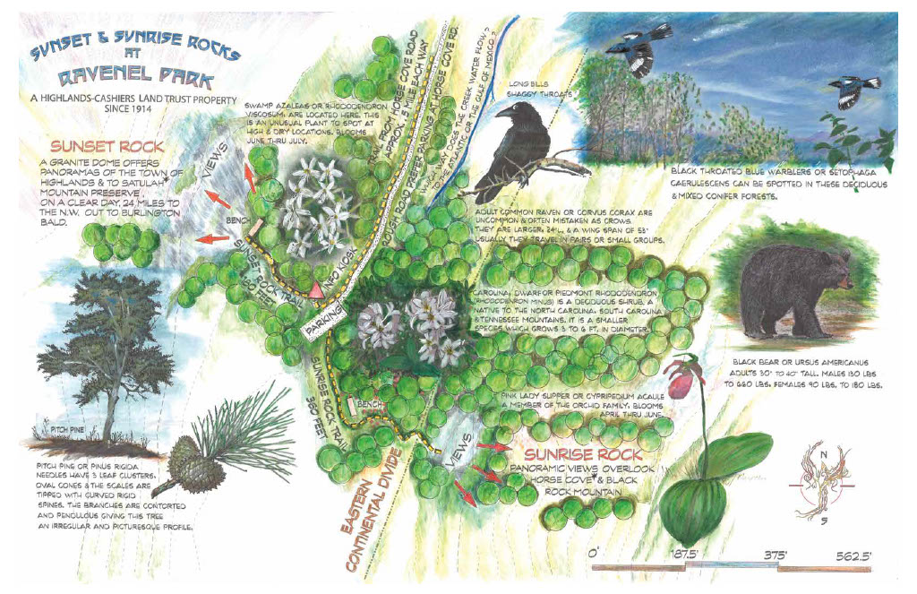
|
|
|
Rhodes Big View
Difficulty: Easy. This viewing area is located on the Macon and Jackson County boarder. From Highlands, take US 64 east to the Macon/Jackson County line. From Cashiers, take US 64 West to the Jackson/Macon County line. This is the popular viewing spot for the infamous "Shadow of the Bear" that occurs in October, November, and February. It overlooks the upper Chattooga River Valley with incredible mountain views. Length: N/A. *Please note that this viewing area is along US Highway 64, therefore extra caution must be taken while visiting. |
|
|
Rhododendron Park
Difficulty: Hard. The trail follows a number of stone stairways as it curves around Big Bear pen Mountain through thick rhododendrons. Length: ~0.6 miles round trip. 
|
|
|
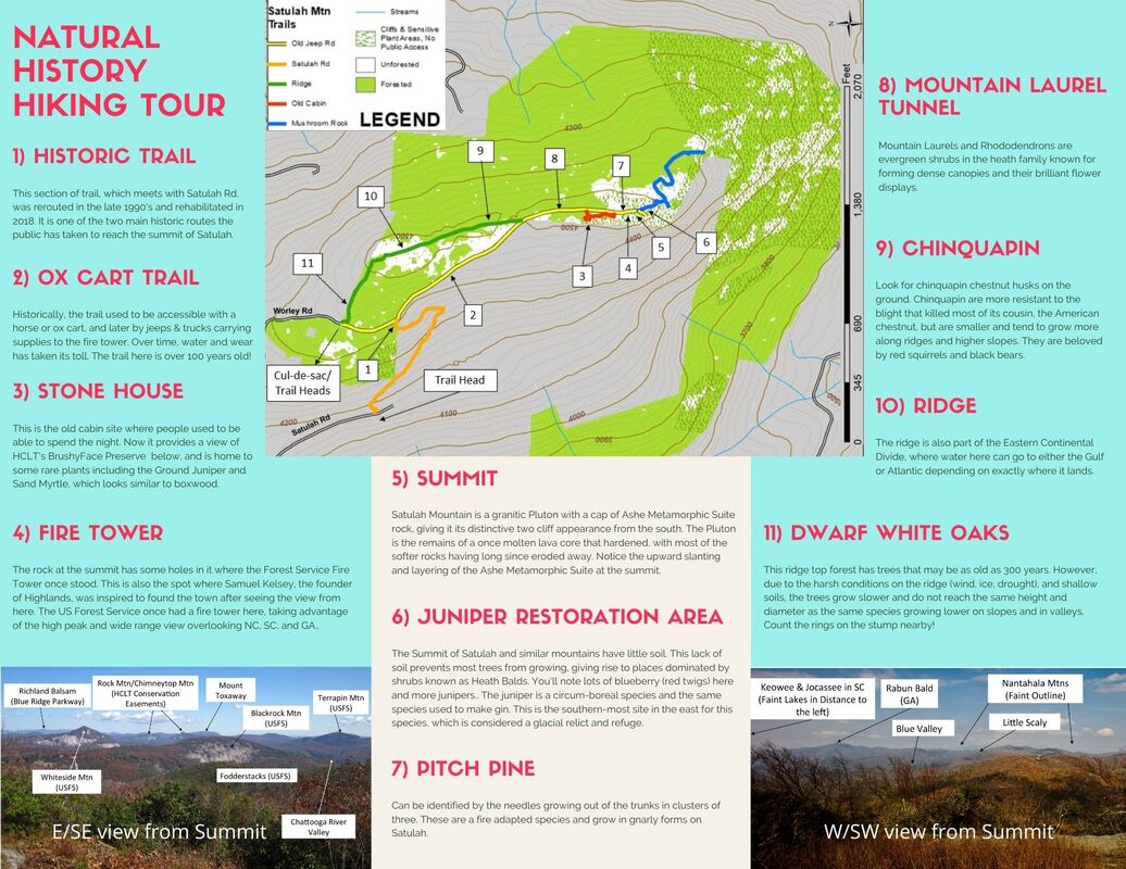
Satulah Mountain
Difficulty: Hard. Beginning in town, the hike goes a mile up paved roads to a cul-de-sac. From there moderate trails traverse a ridge to a southern vista overlooking NC, SC, and GA. Length from town: 3 miles round trip. *Please note that Satulah Road beyond the Worley Road intersection is highly congested and there is nowhere to turn around or a location suitable for dropping off hikers. |


Highlands Plateau Greenway Trail Map
The Highlands Plateau Greenway connects established trail systems within Highlands, NC. It includes our public properties, as well as other partners including: the Town of Highlands, Highlands Biological Station, and Bascom Center for the Visual Arts.
Click map to enlarge.
For more information, please visit their website.